Null

Sheet 1 Sheet 2 Sheet 3 Sheet 4 and 5 Sheet 6 Sheet 7 Sheet 8 Sheet 9 Sheet 10 Sheet 11 and 12

Chronic flooding spots of Mumbai

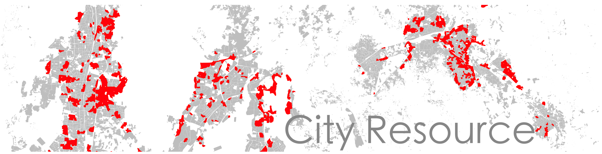
Click on the link above to see a webmap of chronic flooding spots of Mumbai overlaid on a 1926 map. Many of these were previously mud flats or marshes.There is an opacity slider below the map to adjust transparency.

Natural Areas and Open Spaces

The interactive webmap of natural areas and open spaces can be viewed by clicking on the map below. The natural areas have been extracted from the MMR regional plan and the open spaces from MMREIS funded study carried out by Adarkar Associates.

To see a map of walkable open spaces click here. This is considering a distance of 200 mts walking distance from the open space using the existing road network or pathways.

Natural Areas Open Spaces

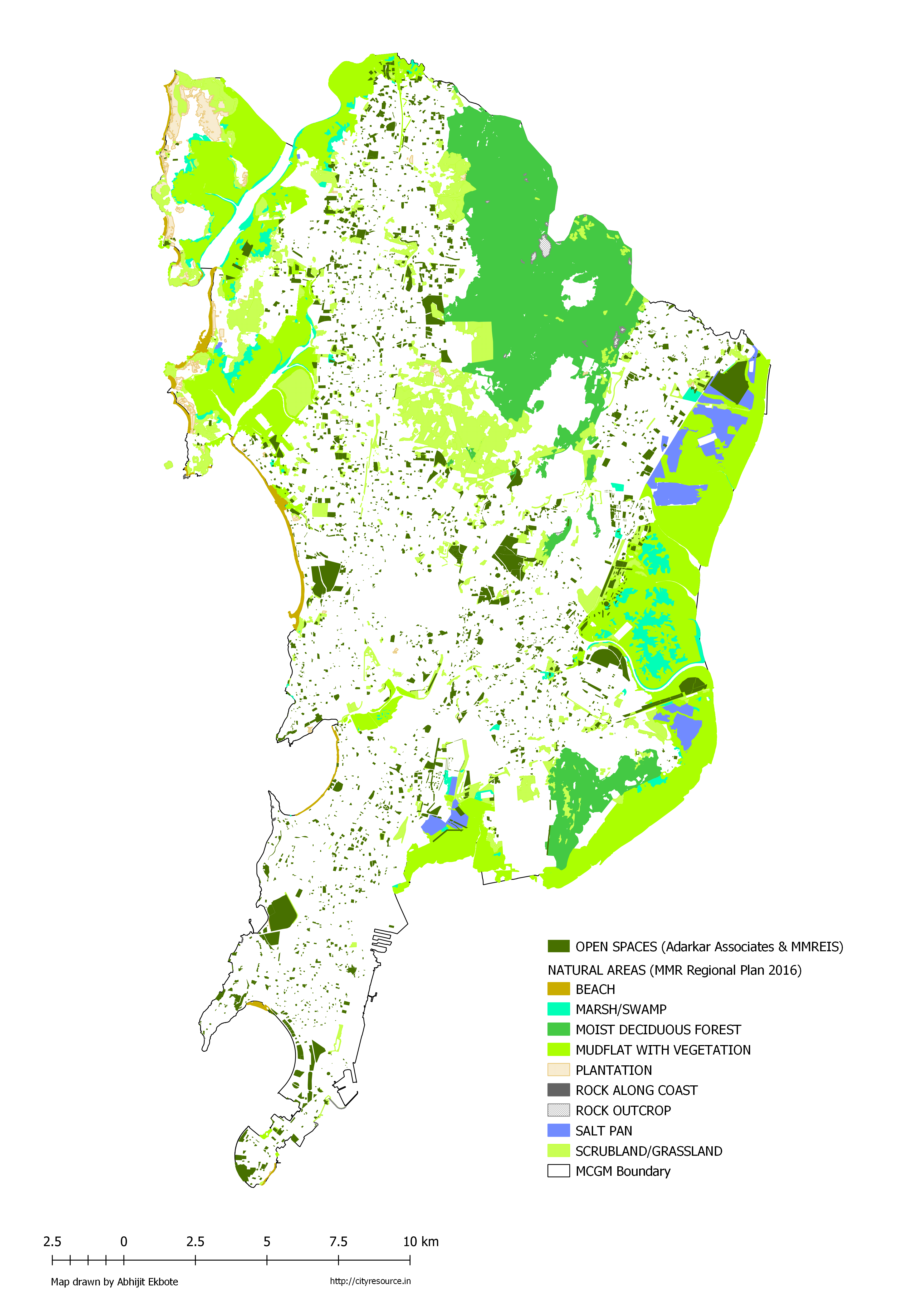
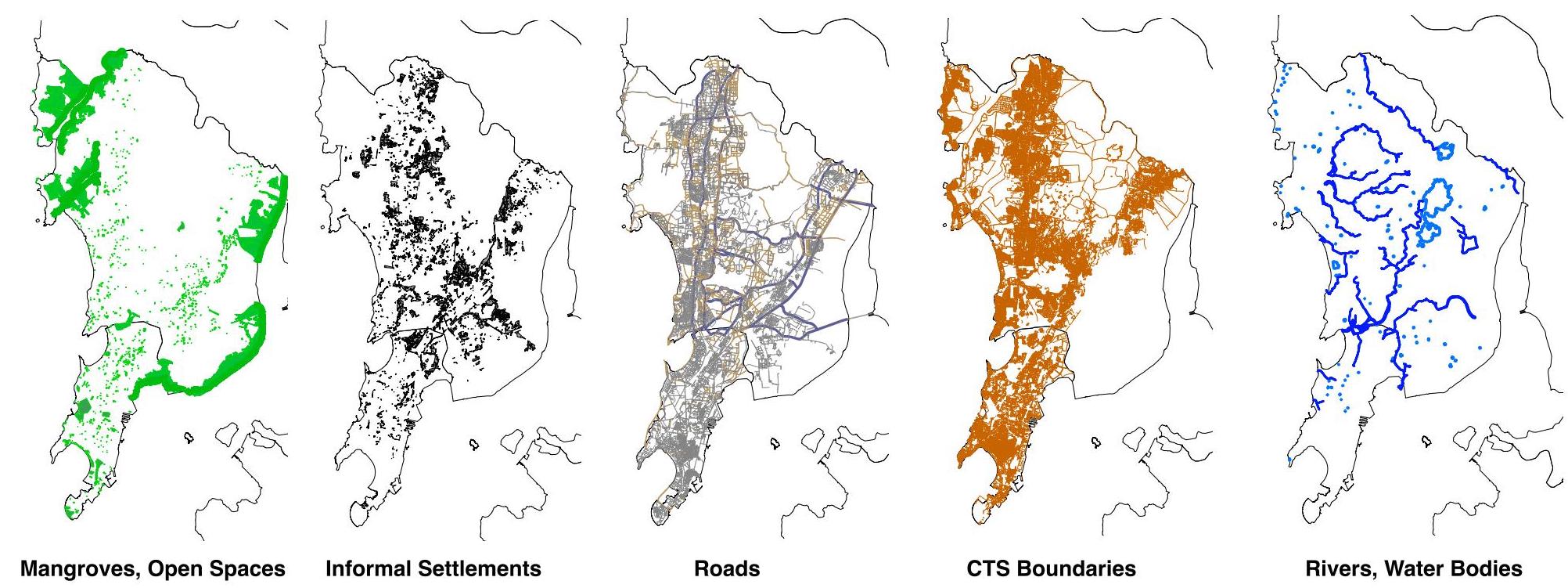
This is an old study carried out by Adarkar Associates and funded by the Mumbai Metropolitan Region Environment Improvement Society (MMREIS) for inventorisation of open spaces in Mumbai. Later I completed a research funded under the Erasmus Plus programme of the European Union at KRVIA, Mumbai, where I focussed on the accessibility parameter in context to the vulnerable settlements. This was under the Building Inclusive Urban Communities (BINUCOM) initiative. This webgis platform is a result of that study where one can query some parameters. While this is an old data (2011), the method and the parameters remain fairly relevant for future documentation and analysis works.

Councillor Wards of Mumbai (based on 2019 election data)

Political Influence map of MMR

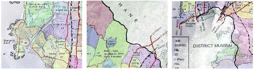
This webmap can help in understanding the maze of election boundaries. Layers, thanks to Data{Meet} Community Maps Group, which helped us put together the 3 hierarchies of elections. In some way, a map showing the 'direct' cumulative political influence over the MMR. It is interesting to see that the MLA boundaries extending to the north and south of MMR are exactly the areas which are coming under the 'extended areas' of MMR (Palghar and Raigad).

Catchment Areas in Deonar (M East Ward)

This webmap can help in understanding the catchment areas in the M East ward of Mumbai. This is created using a 30m resolution DEM. The smaller catchment highlighted in transparent yellow is the one which contains Lallubhai Compound. The map indicates the tendency of water to drain in the direction of the creek. The map also shows that the Mithi river basin is independant of the Deonar basin as they are divided by a ridge originating from the Trombay hills.

2034 Development Plans around Vihar and Powai lakes.

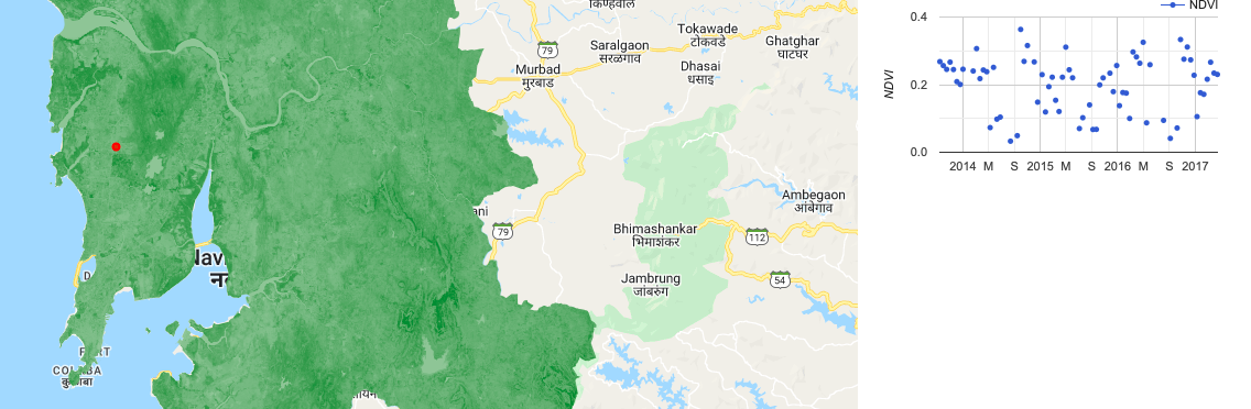
MMR Vegetation Change Application developed on Google Earth Engine

Null

GIS Data layers on Mumbai (MCGM Boundary)

Null

City Resource has created some base layers of Mumbai in .shp format (WGS84). This data becomes useful for us during collaborations with organizations, educational institutions, etc, for carrying out research, documentation, capacity building or proposing area specific urban interventions in Mumbai. This data is currently work-in-progress, hence not available for download.

COVID-19 Vaccination Centres in Mumbai (MCGM Area)

Null

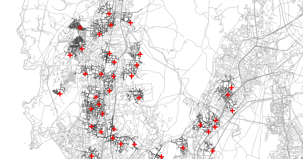
The map indicates interactive points shown as red crosses. MCGM had published a (tabulated) list of 146 active vaccination centres on 13th May 2021, however we have been able to geolocate 115 of them. We are open for suggestions on how to improve the accuracy of this map. So please let us know if something needs an edit. The darker roads indicate an area which is within 1 km road length distance, basically walkable (in most cases). Soon we will be sharing a Google Maps link which will open in your phone's Map app. Map link: https://cityresource.in/vaccination/

COVID 19 - Mumbai

This map contains a information about the Covid-19 cases within Mumbai as per the 11th May 2020 data from MCGM and representatives of community groups. It shows the cluster of Covid-19 hotspots using a Leaflet library. As you click on the cluster, it will zoom in and break into smaller clusters. This can be corelated with the presence of vulnerable settlements who have limited access to water.

Last-Mile Connectivity Map for Metro 2A and 7 (phase1)

Last-Mile connectivity will be crucial if the newly opened elevated Metro 2A and 7 has to become better accessible. If MMRDA runs battery operated smaller buses on these yellow routes shown in the map and sidewalks exist and are obstruction-free, ease of accessibility will definitely increase. The web-map is created using a simple network analysis tool and later coding the layers in Javascript and OpenLayers. For a full screen map click here

DP 2034 Sheets Key Plan (Western Suburbs)

wardsheetsSheet 63 R Central Sheet 72 R South Sheet 73 R South Sheet 74 R Central Sheet 66 R Central Sheet 67 R South & R Central Sheet 68 R South Sheet 69 R South & R Central Sheet 70 R Central Sheet 61 R Central Sheet 62 R South & Central Sheet 64 R Central Sheet 65 P North & R Central Sheet 56 R Central & P North Sheet 57 R Central Sheet 58 R Central Sheet 59 R Central Sheet 60 P North Sheet 51 R Central & South P North Sheet 52 R Central & South Sheet 53 R Central & South Sheet 54 R Central & South Sheet 55 P North Sheet 46 R South & P North Sheet 47 R South & P North R South & P North R South & P North P North P North P North & South P North R South & P North P North P North & South P South P North & South P North P North P North & South K West P South & K West P South P North & South P North K West P North K West P South K West & East P South & K East P South K West K West K West & East K East P South K East K West K West & East K East K East K West K West & East K East K West K West & East H West & East K East K West H West H West & East K East H East H West H West & East H East H West H West & East H East H West

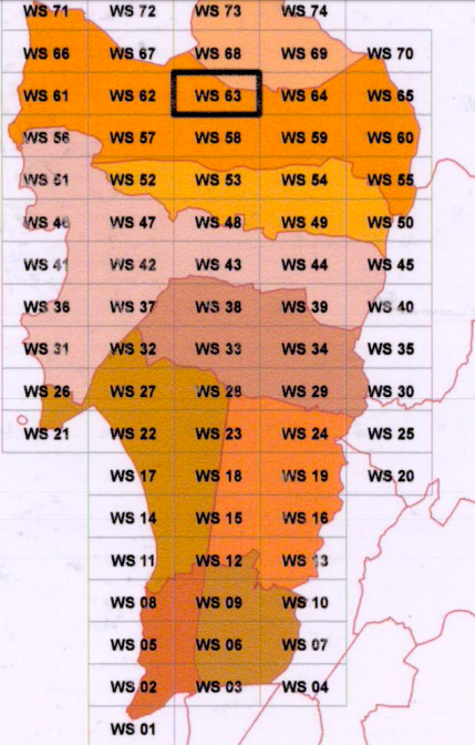
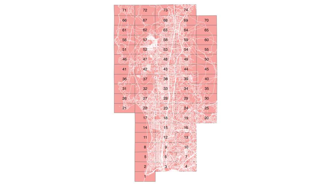
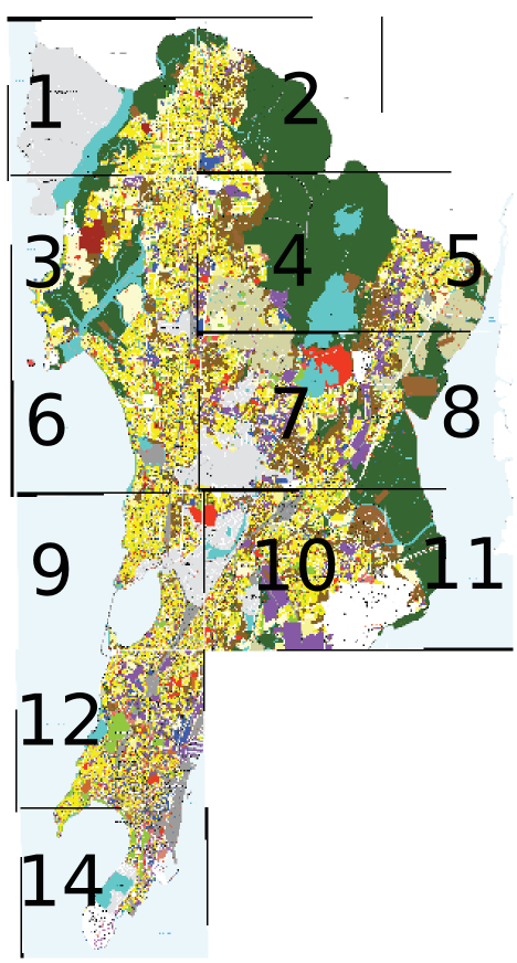
This is a ward map of Mumbai and the 74 no. of DP Sheets of 2034. You can click on it and see the respective DP Sheeet on a satellite image of Mumbai. There is an opacity slider at the bottom which will help you make it transparent. If you want to open the sheet in a new window, then right click on the sheet and select 'open link in new tab'.


To see how the reservation can be developed as ber the DCPR 2034, click HERE

DP 2034 Sheets on Roads (Western Suburbs)

If you want to download a non-georeferenced PDF, you can click on the DP Sheet (road layer is kept as a reference).


html imagemap created with QGIShttps://dpremarks.mcgm.gov.in/dp2034/reports/DP_SHEETS/SM%20Sheets%202034%2008.05.2018/02%20Western%20Suburbs/WS%20%2066.PDF https://dpremarks.mcgm.gov.in/dp2034/reports/DP_SHEETS/SM%20Sheets%202034%2008.05.2018/02%20Western%20Suburbs/WS%20%2067.PDF https://dpremarks.mcgm.gov.in/dp2034/reports/DP_SHEETS/SM%20Sheets%202034%2008.05.2018/02%20Western%20Suburbs/WS%20%2068.PDF https://dpremarks.mcgm.gov.in/dp2034/reports/DP_SHEETS/SM%20Sheets%202034%2008.05.2018/02%20Western%20Suburbs/WS%20%2069.PDF https://dpremarks.mcgm.gov.in/dp2034/reports/DP_SHEETS/SM%20Sheets%202034%2008.05.2018/02%20Western%20Suburbs/WS%20%2070.PDF https://dpremarks.mcgm.gov.in/dp2034/reports/DP_SHEETS/SM%20Sheets%202034%2008.05.2018/02%20Western%20Suburbs/WS%20%2061.PDF https://dpremarks.mcgm.gov.in/dp2034/reports/DP_SHEETS/SM%20Sheets%202034%2008.05.2018/02%20Western%20Suburbs/WS%20%2062.PDF https://dpremarks.mcgm.gov.in/dp2034/reports/DP_SHEETS/SM%20Sheets%202034%2008.05.2018/02%20Western%20Suburbs/WS%20%2063.PDF https://dpremarks.mcgm.gov.in/dp2034/reports/DP_SHEETS/SM%20Sheets%202034%2008.05.2018/02%20Western%20Suburbs/WS%20%2064.PDF https://dpremarks.mcgm.gov.in/dp2034/reports/DP_SHEETS/SM%20Sheets%202034%2008.05.2018/02%20Western%20Suburbs/WS%20%2065.PDF https://dpremarks.mcgm.gov.in/dp2034/reports/DP_SHEETS/SM%20Sheets%202034%2008.05.2018/02%20Western%20Suburbs/WS%20%2060.PDF https://dpremarks.mcgm.gov.in/dp2034/reports/DP_SHEETS/SM%20Sheets%202034%2008.05.2018/02%20Western%20Suburbs/WS%20%2059.PDF https://dpremarks.mcgm.gov.in/dp2034/reports/DP_SHEETS/SM%20Sheets%202034%2008.05.2018/02%20Western%20Suburbs/WS%20%2058.PDF https://dpremarks.mcgm.gov.in/dp2034/reports/DP_SHEETS/SM%20Sheets%202034%2008.05.2018/02%20Western%20Suburbs/WS%20%2057.PDF https://dpremarks.mcgm.gov.in/dp2034/reports/DP_SHEETS/SM%20Sheets%202034%2008.05.2018/02%20Western%20Suburbs/WS%20%2056.PDF https://dpremarks.mcgm.gov.in/dp2034/reports/DP_SHEETS/SM%20Sheets%202034%2008.05.2018/02%20Western%20Suburbs/WS%20%2071.PDF https://dpremarks.mcgm.gov.in/dp2034/reports/DP_SHEETS/SM%20Sheets%202034%2008.05.2018/02%20Western%20Suburbs/WS%20%2072.PDF https://dpremarks.mcgm.gov.in/dp2034/reports/DP_SHEETS/SM%20Sheets%202034%2008.05.2018/02%20Western%20Suburbs/WS%20%2073.PDF https://dpremarks.mcgm.gov.in/dp2034/reports/DP_SHEETS/SM%20Sheets%202034%2008.05.2018/02%20Western%20Suburbs/WS%20%2074.PDF https://dpremarks.mcgm.gov.in/dp2034/reports/DP_SHEETS/SM%20Sheets%202034%2008.05.2018/02%20Western%20Suburbs/WS%20%2051.PDF https://dpremarks.mcgm.gov.in/dp2034/reports/DP_SHEETS/SM%20Sheets%202034%2008.05.2018/02%20Western%20Suburbs/WS%20%2052.PDF https://dpremarks.mcgm.gov.in/dp2034/reports/DP_SHEETS/SM%20Sheets%202034%2008.05.2018/02%20Western%20Suburbs/WS%20%2053.PDF https://dpremarks.mcgm.gov.in/dp2034/reports/DP_SHEETS/SM%20Sheets%202034%2008.05.2018/02%20Western%20Suburbs/WS%20%2054.PDF https://dpremarks.mcgm.gov.in/dp2034/reports/DP_SHEETS/SM%20Sheets%202034%2008.05.2018/02%20Western%20Suburbs/WS%20%2055.PDF https://dpremarks.mcgm.gov.in/dp2034/reports/DP_SHEETS/SM%20Sheets%202034%2008.05.2018/02%20Western%20Suburbs/WS%20%2046.PDF https://dpremarks.mcgm.gov.in/dp2034/reports/DP_SHEETS/SM%20Sheets%202034%2008.05.2018/02%20Western%20Suburbs/WS%20%2047.PDF https://dpremarks.mcgm.gov.in/dp2034/reports/DP_SHEETS/SM%20Sheets%202034%2008.05.2018/02%20Western%20Suburbs/WS%20%2048.PDF https://dpremarks.mcgm.gov.in/dp2034/reports/DP_SHEETS/SM%20Sheets%202034%2008.05.2018/02%20Western%20Suburbs/WS%20%2049.PDF https://dpremarks.mcgm.gov.in/dp2034/reports/DP_SHEETS/SM%20Sheets%202034%2008.05.2018/02%20Western%20Suburbs/WS%20%2050.PDF https://dpremarks.mcgm.gov.in/dp2034/reports/DP_SHEETS/SM%20Sheets%202034%2008.05.2018/02%20Western%20Suburbs/WS%20%2041.PDF https://dpremarks.mcgm.gov.in/dp2034/reports/DP_SHEETS/SM%20Sheets%202034%2008.05.2018/02%20Western%20Suburbs/WS%20%2042.PDF https://dpremarks.mcgm.gov.in/dp2034/reports/DP_SHEETS/SM%20Sheets%202034%2008.05.2018/02%20Western%20Suburbs/WS%20%2043.PDF https://dpremarks.mcgm.gov.in/dp2034/reports/DP_SHEETS/SM%20Sheets%202034%2008.05.2018/02%20Western%20Suburbs/WS%20%2044.PDF https://dpremarks.mcgm.gov.in/dp2034/reports/DP_SHEETS/SM%20Sheets%202034%2008.05.2018/02%20Western%20Suburbs/WS%20%2045.PDF https://dpremarks.mcgm.gov.in/dp2034/reports/DP_SHEETS/SM%20Sheets%202034%2008.05.2018/02%20Western%20Suburbs/WS%20%2036.PDF https://dpremarks.mcgm.gov.in/dp2034/reports/DP_SHEETS/SM%20Sheets%202034%2008.05.2018/02%20Western%20Suburbs/WS%20%2037.PDF https://dpremarks.mcgm.gov.in/dp2034/reports/DP_SHEETS/SM%20Sheets%202034%2008.05.2018/02%20Western%20Suburbs/WS%20%2038.PDF https://dpremarks.mcgm.gov.in/dp2034/reports/DP_SHEETS/SM%20Sheets%202034%2008.05.2018/02%20Western%20Suburbs/WS%20%2039.PDF https://dpremarks.mcgm.gov.in/dp2034/reports/DP_SHEETS/SM%20Sheets%202034%2008.05.2018/02%20Western%20Suburbs/WS%20%2040.PDF https://dpremarks.mcgm.gov.in/dp2034/reports/DP_SHEETS/SM%20Sheets%202034%2008.05.2018/02%20Western%20Suburbs/WS%20%2031.PDF https://dpremarks.mcgm.gov.in/dp2034/reports/DP_SHEETS/SM%20Sheets%202034%2008.05.2018/02%20Western%20Suburbs/WS%20%2032.PDF https://dpremarks.mcgm.gov.in/dp2034/reports/DP_SHEETS/SM%20Sheets%202034%2008.05.2018/02%20Western%20Suburbs/WS%20%2033.PDF https://dpremarks.mcgm.gov.in/dp2034/reports/DP_SHEETS/SM%20Sheets%202034%2008.05.2018/02%20Western%20Suburbs/WS%20%2034.PDF https://dpremarks.mcgm.gov.in/dp2034/reports/DP_SHEETS/SM%20Sheets%202034%2008.05.2018/02%20Western%20Suburbs/WS%20%2035.PDF https://dpremarks.mcgm.gov.in/dp2034/reports/DP_SHEETS/SM%20Sheets%202034%2008.05.2018/02%20Western%20Suburbs/WS%20%2026.PDF https://dpremarks.mcgm.gov.in/dp2034/reports/DP_SHEETS/SM%20Sheets%202034%2008.05.2018/02%20Western%20Suburbs/WS%20%2027.PDF https://dpremarks.mcgm.gov.in/dp2034/reports/DP_SHEETS/SM%20Sheets%202034%2008.05.2018/02%20Western%20Suburbs/WS%20%2028.PDF https://dpremarks.mcgm.gov.in/dp2034/reports/DP_SHEETS/SM%20Sheets%202034%2008.05.2018/02%20Western%20Suburbs/WS%20%2029.PDF https://dpremarks.mcgm.gov.in/dp2034/reports/DP_SHEETS/SM%20Sheets%202034%2008.05.2018/02%20Western%20Suburbs/WS%20%2030.PDF https://dpremarks.mcgm.gov.in/dp2034/reports/DP_SHEETS/SM%20Sheets%202034%2008.05.2018/02%20Western%20Suburbs/WS%20%2021.PDF https://dpremarks.mcgm.gov.in/dp2034/reports/DP_SHEETS/SM%20Sheets%202034%2008.05.2018/02%20Western%20Suburbs/WS%20%2022.PDF https://dpremarks.mcgm.gov.in/dp2034/reports/DP_SHEETS/SM%20Sheets%202034%2008.05.2018/02%20Western%20Suburbs/WS%20%2023.PDF https://dpremarks.mcgm.gov.in/dp2034/reports/DP_SHEETS/SM%20Sheets%202034%2008.05.2018/02%20Western%20Suburbs/WS%20%2024.PDF https://dpremarks.mcgm.gov.in/dp2034/reports/DP_SHEETS/SM%20Sheets%202034%2008.05.2018/02%20Western%20Suburbs/WS%20%2025.PDF https://dpremarks.mcgm.gov.in/dp2034/reports/DP_SHEETS/SM%20Sheets%202034%2008.05.2018/02%20Western%20Suburbs/WS%20%2017.PDF https://dpremarks.mcgm.gov.in/dp2034/reports/DP_SHEETS/SM%20Sheets%202034%2008.05.2018/02%20Western%20Suburbs/WS%20%2018.PDF https://dpremarks.mcgm.gov.in/dp2034/reports/DP_SHEETS/SM%20Sheets%202034%2008.05.2018/02%20Western%20Suburbs/WS%20%2019.PDF https://dpremarks.mcgm.gov.in/dp2034/reports/DP_SHEETS/SM%20Sheets%202034%2008.05.2018/02%20Western%20Suburbs/WS%20%2020.PDF https://dpremarks.mcgm.gov.in/dp2034/reports/DP_SHEETS/SM%20Sheets%202034%2008.05.2018/02%20Western%20Suburbs/WS%20%2014.PDF https://dpremarks.mcgm.gov.in/dp2034/reports/DP_SHEETS/SM%20Sheets%202034%2008.05.2018/02%20Western%20Suburbs/WS%20%2015.PDF https://dpremarks.mcgm.gov.in/dp2034/reports/DP_SHEETS/SM%20Sheets%202034%2008.05.2018/02%20Western%20Suburbs/WS%20%2016.PDF https://dpremarks.mcgm.gov.in/dp2034/reports/DP_SHEETS/SM%20Sheets%202034%2008.05.2018/02%20Western%20Suburbs/WS%20%2011.PDF https://dpremarks.mcgm.gov.in/dp2034/reports/DP_SHEETS/SM%20Sheets%202034%2008.05.2018/02%20Western%20Suburbs/WS%20%2012.PDF https://dpremarks.mcgm.gov.in/dp2034/reports/DP_SHEETS/SM%20Sheets%202034%2008.05.2018/02%20Western%20Suburbs/WS%20%2013.PDF https://dpremarks.mcgm.gov.in/dp2034/reports/DP_SHEETS/SM%20Sheets%202034%2008.05.2018/02%20Western%20Suburbs/WS%20%2008.PDF https://dpremarks.mcgm.gov.in/dp2034/reports/DP_SHEETS/SM%20Sheets%202034%2008.05.2018/02%20Western%20Suburbs/WS%20%2009.PDF https://dpremarks.mcgm.gov.in/dp2034/reports/DP_SHEETS/SM%20Sheets%202034%2008.05.2018/02%20Western%20Suburbs/WS%20%2010.PDF https://dpremarks.mcgm.gov.in/dp2034/reports/DP_SHEETS/SM%20Sheets%202034%2008.05.2018/02%20Western%20Suburbs/WS%20%2005.PDF https://dpremarks.mcgm.gov.in/dp2034/reports/DP_SHEETS/SM%20Sheets%202034%2008.05.2018/02%20Western%20Suburbs/WS%20%2006.PDF https://dpremarks.mcgm.gov.in/dp2034/reports/DP_SHEETS/SM%20Sheets%202034%2008.05.2018/02%20Western%20Suburbs/WS%20%2007.PDF https://dpremarks.mcgm.gov.in/dp2034/reports/DP_SHEETS/SM%20Sheets%202034%2008.05.2018/02%20Western%20Suburbs/WS%20%2002.PDF https://dpremarks.mcgm.gov.in/dp2034/reports/DP_SHEETS/SM%20Sheets%202034%2008.05.2018/02%20Western%20Suburbs/WS%20%2003.PDF https://dpremarks.mcgm.gov.in/dp2034/reports/DP_SHEETS/SM%20Sheets%202034%2008.05.2018/02%20Western%20Suburbs/WS%20%2004.PDF https://dpremarks.mcgm.gov.in/dp2034/reports/DP_SHEETS/SM%20Sheets%202034%2008.05.2018/02%20Western%20Suburbs/WS%20%2001.PDF

Census Wards of Mumbai

Null

Click on the image above to see a web map showing the census wards of Mumbai (western suburbs). Currently under the BINUCOM program at KRVIA, open spaces are being studied with respect to the densities across the city. This would help in understanding the disparity levels.

Please be a little patient, as the map tiles take about a minute to load.

Old Streams of Mumbai

Null

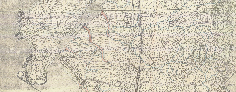
Click on the image above to see a web map showing old streams in the K West ward of Mumbai (part of western suburbs). The streams are traced from a 1924 map of Mumbai and placed on the base layer of Open Street Map. You can see instructions on 'how to use the map' after you click on the image above. This can be useful in understanding the natural drainage pattern that existed before urbanization started post 1950 in this area. A lot of these areas experience flooding during days of heavy monsoon and high tide.

Please be a little patient, as the 1924 map takes about a minute to load.

Catchment Area of Dahisar River, Mumbai

Null

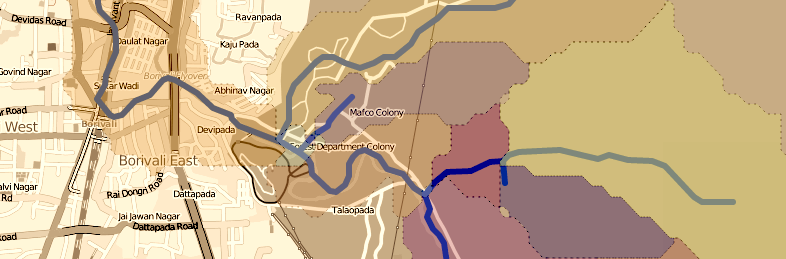
Click on the image above to see a web map showing the catchment areas of Dahisar River. This river, flowing in the east-west direction originates from the hills of Sanjay Gandhi National Park, a protected forest located in the north of Mumbai's suburbs. This river also flooded extensively during the catastrophic floods of 2006. A lot of that can be attributed to the way in which its course has been altered. The layer of catchment areas can be made transparent so that the OSM layer can be seen clearly.

Mumbai ELU (Existing Land Use - 2012)

Null

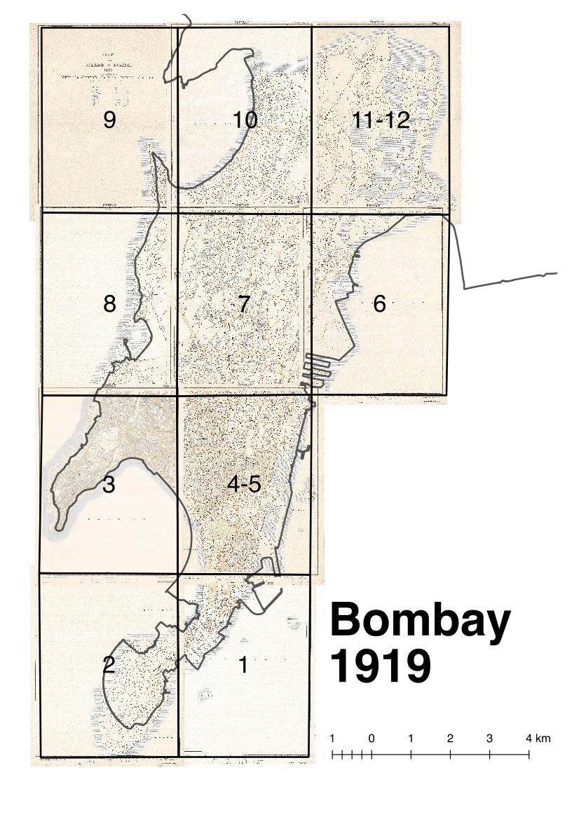
Click on the link above to see the key map of Mumbai's Existing Land Use map tiles. You can use this key map to download the specific tiles you wish to download. The tiles are georeferenced maps, which can be opened in any GIS software, such as QGIS. The tiles are originally downloaded from the MCGM website. They were then stitched and geo-referenced.
The ELU was prepared by the MCGM in 2012. Initially it was opened for suggestions and objections and was found to have many errors. It was corrected later and used for the preparation of DP. Since these sheets are now taken off the MCGM website, we feel that they are a useful resource for academic purposes.
Given below is the list of geo-referenced tiles which can be downloaded:-

p1 and 2

p3 and 6

p4 and 5

p7 and 8

p10 and 11

p9

p12

p14